I had a week off, and I was itching to take Romeo Victor on a long cross country. The ideal cross country for me is under 800 nautical miles, or about two legs of two and a half hours. This allows us to arrive feeling fairly energetic, ready to explore the local area. We wanted to go somewhere different. We wanted cooler weather, hiking, biking and sight-seeing. We found our destination west of Memphis in Santa Fe, New Mexico. So,on Thursday, August27, 2009, The Missus and I loaded up the seven and filed IFR to Borger, TX. This was longer than I like for the first leg, but the weather around Oklahoma City was stinky, and I decided to go past the bad

weather before landing. The thunderstorms around this area were easily avoided using the Garmin 696. I had a slight headwind going westbound, but the fuel-sipping Lycoming engine running lean-of-peak gives me plenty of range (about five and a half hours with full tanks).
The folks at the FBO at Borger were very friendly, sending us off in their courtesy car for a lunch a the local Subway. Fuel was $3.69 per gallon, not bad at current market prices.

Continuing on to Santa Fe, we went VFR at 10,500 feet. I decided to fly to the southwest in order to approach Santa Fe from the south. This avoids the higher mountainous terrain to the east of Santa Fe. As it turned out, I didn't have much choice because there was a pretty good thunderstorm to the southeast of Santa Fe moving directly across our path. Using the 696, I deviated about 20 miles further to the south before turning inbound to Santa Fe. The dark wall of clouds on our right correlated with lots of red, yellow and lightning bolts on the Garmin display. It was a bit bumpy on the back side of the weather but we made it to the airport without penetrating anything significant.


We were met by a vehicle at the taxiway which directed us to parking at Santa Fe AirCenter. The lady driving the vehicle helped us with the canopy cover and called to have our rental car brought to the airplane. The car was there in about two minutes. This is a very nice FBO, and I recommend it if you fly into Santa Fe.
We drove the few miles into Santa Fe and walked around the downtown plaza area where there are lots of tourist shops. There is some history in this town that predates even the pilgrims at Plymoth Rock. Santa Fe was originally discovered by Spanish conquistadores in about 1600 as they moved up from what is now Mexico. We toured the old church called San Miguel which was built around 1600 and destroyed by the Pueblo revolt in 1680. It was then rebuilt in 1710. We also checked out the Cathedral of St Francis, built in the second half of the nineteenth century.

Leaving Santa Fe, we traveled north, passing a number of Casinos run by the local Native
Americans and arrived at our hotel in White Rock, just a few miles from Los Alamos. We decided to stay here because it was central to a lot of the places we wanted to visit. We were only a forty minute drive to downtown Santa Fe from here with lots of hiking just a few minutes away. We checked into the Hampton Inn and had dinner at the one local restaurant, The Bandelier Grill. Not too bad.
Friday morning we awoke to a cloudless sky. We drove about ten miles to Bandelier National Monument, paid our $12 admission fee and went to the visitor center at Frijoles Canyon for a briefing from a very nice and helpful lady. This area is an archeological excavation of the home of hundreds of Ancestral Pueblo people who lived here since at least the year 1200. There is some evidence of human activity in this area dating back more than

10,000 years. This was a nice hike along a valley surrounded on both sides by cliffs. The south-facing cliffs were excavated into caves which were homes to many of the people. Others lived in structures on the valley floor. We toured the cliffs then hiked another half mile to Alcove House, which required climbing ladders to a height of 140 feet off the canyon floor.

After lunch at the deli located at the visitor center, we drove about ten miles to begin another hike at Cerro Grande. This was about four miles round trip up a fairly steep trail to a height of 10,100 feet MSL.
Finally, we drove the few miles into Los Alamos for tour through the free Bradbury Science Museum. This was all about the Manhattan Project, detailing the development of the atomic bomb. They did this in 27 months. Truly amazing stuff.
Saturday we drove to Taos, about an hour and a half to the north. There we rented a couple of bikes at Gearing Up Bicycle Shop, another place with friendly, helpful folks. After biking for a couple of hours, we ate lunch then returned the bikes and toured the town on foot. There are lots of shops selling all sorts of tourist stuff. I picked up a couple of tee shirts and a dream catcher for my daughter.
After this, we drove up to the Taos ski resort just to check it out. We rode up the one operating lift (ten bucks per person) and talked to a lady at one of the mountain side condo rentals about maybe coming here this winter. This looks like it would be fun to ski, although Taos lacks the high-speed deta chable lifts that I'm accustomed to in Park City, Vail and other bigger resorts.
We wanted to tour the Taos Pueblo, but it was closed, so we drove down to the Taos airport where I talked to a very helpful FBO attendant named Gary about flying into Taos in the winter. With the right type of weather, and the possibility of heated hangar storage for Romeo Victor (fifty bucks per day), I might be able to swing it.

Just a few miles from the Taos airport is the Rio Grande Gorge Bridge, another must-see spectacular site in this area. We walked half way across the bridge to an observation bridge where one can stand and take pictures. An eighteen wheeler thundered past while we were standing there, making the whole bridge shake. Yikes!
After the drive back to White Rock, we decided to go to Buffalo Thunder Casino for dinner at Turquoise Bar and Grill, inside the casino. They have a ten dollar prime rib that is very good. I managed to part with about ten bucks to feed the poker machine before leaving. I did not inherit the gambling gene from my dear old dad who truly was a craps-playing gamer by nature.
Sunday morning we made our longest drive, passing through Santa Fe, continuing on another twenty miles or so to Kasha Katuwe National Monument for more hiking. I don't know how many times I can say "spectacular," but it certainly applies to this place. There is about a two and a half mile climb through a narrow canyon to a mesa with breathtaking views. It was rigorous enough that we decided to head back into Santa Fe for lunch. We chose The Ore House near the plaza. This turned out to be our best meal of all the New Mexican meals that we had. I recommend the Poblano Relleno. Delicious!

Sunday afternoon we returned to White Rock. One thing we discovered was a spectacular (there's that word again) view just a couple of miles from our hotel where an overlook was situated above a large gorge where the Rio

Grande runs through. Here I am standing there in one of my souvenir t shirts!
Sunday night it finally rained on us, so we stayed in at the Hampton and ordered pizza from the place right next door. Free delivery!
All too soon, Monday morning arrived and it was time to go home. The weather was pretty

good although there was a weak front stretching across the mid part of Oklahoma with an undercast of clouds a good part of the way. So I filed IFR to Sundance, Oklahoma, on the north side of Oklahoma City. The FBO at Santa Fe let us drive out to the airplane on the ramp to load up, and we departed at 0800 local time. The trip home was uneventful, consisting of two legs of two and a half hours each. Mary read her Kindle and I listened to XM radio most of the way. We ate lunch in Oklahoma City with the aid of a courtesy car from the nice folks at the Sundance FBO.
It's always nice to get home, but we're already thinking about the next trip!


 Click on the link above to go to more pictures from the Carlsbad trip. We picked New Mexico to visit because it had the best weather in the country. But wouldn't you know it, the weather turned stinky just in time for our return to Memphis. As you can see on the Garmin, the weather around Dallas and south of there was nasty. Fortunately, we were able to deviate to the north and avoid any significant weather, although our IFR skills were required.
 Click on the link above to go to more pictures from the Carlsbad trip. We picked New Mexico to visit because it had the best weather in the country. But wouldn't you know it, the weather turned stinky just in time for our return to Memphis. As you can see on the Garmin, the weather around Dallas and south of there was nasty. Fortunately, we were able to deviate to the north and avoid any significant weather, although our IFR skills were required.
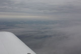


 Just for the heck of it, we flew a practice ILS approach back into Carlsbad. Everything in Romeo Victor is working just fine.
 t an hour drive from the Holiday Inn Express in Carlsbad to the visitor's center at Guadalupe Mountains National Parks just across the state border in northwest Texas. Despite being about 3,500 feet above sea level, the terrain around Carlsbad is pretty flat until you get to the mountains to the south and west. The hiking trails in this area offer anything you want, from short and flat to steep, long and rocky. We chose two short hikes for the day. The first was called Devil's Hall and was 4.2 miles round trip. This was a moderately intense hike and included a bit of scrambling across rocks.


